When Tibetans refer to ‘Tibet’ they are talking about the entity comprising the three provinces of U-Tsang, Kham and Amdo. The two Tibetan provinces of Kham and Amdo are now largely incorporated into the Chinese provinces of Qinghai and Sichuan (upper/right regions in brown on the map below). Tibet’s traditional territory now accounts for one quarter of the landmass of today’s People’s Republic of China.
When China talks about ‘Tibet’, they are referring only to the Tibet Autonomous Region (TAR), an administrative region created in 1965. The TAR (lower/left regions in brown in the map below) comprises less than half the total Tibetan lands and contains only a third of the total Tibetan population.
China occupied Tibet in 1949/50. For an overview of the impact of China’s policies on Tibet – on the human rights situation and on everyday life for Tibetans in Tibet – over the last 60 years, please visit the Network’s website: www.chinasfailedtibetpolicies.org
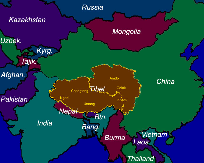
Tibet’s traditional three provinces are shown along with other regional names. Following centuries of isolation, many Tibetans may think of themselves as Khampas or Amdowas before they refer to themselves as Tibetans (not unlike, say, people from Texas). However they will invariably consider themselves Tibetans and not Chinese, in spite of half a century of intensive Chinese efforts to erase the notion of a separate Tibetan identity.
Facts About Tibet:
Land Size: The total size of Tibet (all three traditional provinces) is 2.5 million square kilometres (or 965,000 square miles). The TAR, consisting of U-Tsang and a small portion of Kham, is 1.2 million square kilometres in size. More than half the landmass of Tibet lies outside of the TAR.
Population:
There are around 6 million Tibetans; 2.7 million live in the TAR and the remainder in the Tibetan areas outside the TAR. There is also an undetermined number of Chinese in the Tibetan areas with the Tibetan Government in Exile estimating that the Chinese now outnumber Tibetans in Tibet. Additionally, approximately 120,000 Tibetans live in exile.
Legal Status:
Occupied by China.
Government:
The Communist Party of China rules occupied Tibet. However Tibetans, both inside Tibet and in exile, recognise the Tibetan Government in Exile based in Dharamsala, India as their legitimate government.
Head of State:
All Tibetans recognise His Holiness the 14th Dalai Lama as the leader of Tibet. The Dalai Lama has lived in Dharamsala, India since 1959. In March 2011, His Holiness announced his intention to devolve his political authority; in May 2011 the Tibetan Charter of the exiled community was amended which means His Holiness is no longer the Head of State of the Tibetan people, though Tibetans will continue to regard him as such. His Holiness’ political responsibilities were shared between the elected Sikyong, the Executive (Kalons), the Parliament and the Judiciary. The Head of State under China’s occupation is the Chinese President Xi Jinping.
Administration:
Under Chinese rule, the Tibetan landmass has been divided into the following administrative units:
a) Tibet Autonomous Region.
b) Haibei [Tibetan: Tsochang] Tibetan Autonomous Prefecture, Hainan [Tsolho] Tibetan Autonomous Prefecture, Huangan [Malho] Tibetan Autonomous Prefecture, Guoluo [Golog] Tibetan Autonomous Prefecture, Yushu [Jyekundo] Tibetan Autonomous Prefecture and Haixi [Tsonub] Mongolian-Tibetan Autonomous Prefecture in Qinghai Province.
c) Tianzu [Pari] Tibetan Autonomous County and Gannan [Gannan] Tibetan Autonomous Prefecture in Gansu Province.
d) Aba [Ngaba] Tibetan-Qiang Autonomous Prefecture, Ganzi [Kardze] Tibetan Autonomous Prefecture and Mili [Mili] Tibetan Autonomous County in Sichuan Province,
e) Diqing [Dechen] Tibetan Autonomous Prefecture in Yunnan Province.
Language:
Tibetan. The official language in Tibet following the occupation is Chinese.
Religion:
The majority of Tibetans practice Tibetan Buddhism. Other religions include Bon, Islam and Christianity.
Economy:
Tibetans work predominantly in the agriculture and animal husbandry sectors. Chinese are predominantly in government, commerce and the service sectors.
Major Rivers:
Yarlung Tsangpo (Brahmaputra in India), Machu (Yellow River in China), Drichu (Yangtse in China), Senge Khabab (Indus in India), Phungchu (Arun in India), Gyalmo Ngulchu (Salween in Burma) and Zachu (Mekong in Thailand, Vietnam, Cambodia, Laos).
Bordering Countries:
India, Nepal, Bhutan, Burma, East Turkestan (north of Tibet, not shown; also occupied by China – Xinjiang Uighur Autonomous Region), China
Average Altitude:
4,000 metres or 13,000 feet above sea level.
China’s Policies in Tibet:
For an overview of the impact of China’s policies in Tibet between 1951 and 2011, please visit the Network’s website: www.chinasfailedtibetpolicies.org